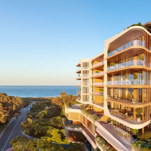
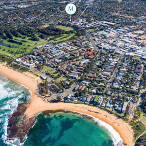
Sydney's newest beachfront city: NSW Gov to unlock 4,300 new homes on Kurnell peninsula

A State-Assessed Rezoning Proposal for the Kurnell Peninsula is now on public exhibition, setting out a plan to deliver up to 4,300 homes alongside new retail, tourism and public open space on a 210-hectare coastal site.
The proposal, backed by the Minns Labor Government, would transform a former sand mining area along Captain Cook Drive into a mixed-use precinct delivered over approximately 20 years.
In addition to housing, the plan includes more than 7,000 sqm of retail and commercial space, new community facilities and approximately 116 hectares of open space, equating to more than half the site.

Rezoning framework enables mixed-use development
The rezoning application seeks to amend planning controls under the State Environmental Planning Policy (Precincts—Central River City) and the Sutherland Shire Local Environmental Plan 2015.
Its primary objective is to enable a broader range of land uses across the site, including residential, employment, tourism and community uses, while also formalising environmental protections and land management outcomes .
The proposal has progressed through the state-led rezoning pathway after being identified as a project of regional significance, supported by several years of technical studies and agency consultation .
Development would occur in stages, aligned with the progressive closure and remediation of the existing sand mine.
Master plan structured around three precincts
The accompanying urban design report outlines an indicative master plan that divides the site into three primary precincts, anchored by a town centre in the western portion of the site.
The town centre is planned as the first stage of development, located on land that has already been remediated. It is intended to accommodate higher-density housing, retail, and community uses.

Additional precincts extend toward Bate Bay and Boat Harbour, with built form responding to environmental conditions and proximity to the coastline.
The design framework identifies distinct local character areas, with the master plan structured to reflect “unique natural qualities” across the site.
Open space forms core of the design approach
A key component of the proposal is the allocation of approximately 116 hectares to open space and ecological land.
This includes:
- Three district parks
- Nine local parks
- Sports fields
- Coastal and ecological corridors
- Two kilometres of publicly accessible beachfront along Bate Bay
The urban design report positions this open space network as central to the structure of the development, rather than ancillary to it.
It is intended to support ecological regeneration, provide recreational amenity and create a connected network across the peninsula.
The plan includes north–south ecological corridors, expanded wetland systems and pedestrian and cycling links designed to connect residential areas to the coastline and open space areas .
Housing mix and affordability
The proposal includes approximately 4,300 dwellings across a range of housing types.
This includes high-density apartments, medium-density housing, townhouses and seniors housing.
Affordable housing provision is identified at approximately 240 dwellings, alongside a smaller component of social housing.
The master plan emphasises housing diversity, with the intent of accommodating a range of household types and age groups within the development.

Built form controls and height limits
Proposed building heights across the site range from three to 12 storeys.
These controls are set out within the rezoning application and are intended to manage visual impact, maintain view corridors and ensure compatibility with the coastal landscape.
Floor space ratios and height limits are applied across different parts of the site to reflect varying environmental conditions and proximity to open space and the coastline .
Higher density is generally concentrated within the town centre, with lower-scale development toward the coastal edge and environmentally sensitive areas.
Retail, tourism and employment uses
In addition to residential development, the proposal includes retail, commercial and tourism uses.
This includes:
- Approximately 7,000–9,800sqm of retail and commercial floor space
- A full-line supermarket
- Food and beverage uses
- Tourism accommodation, including hotel and short-stay options
The proposal also identifies employment outcomes, with the development expected to support jobs both during construction and in ongoing operations.
These uses are concentrated within the town centre and key activity areas across the site.
Infrastructure and access
The proposal includes upgrades to Captain Cook Drive, which provides the primary access to the peninsula.
These upgrades are intended to improve traffic flow and support emergency access.
The transport strategy also incorporates:
- Internal road networks
- Walking and cycling connections
- Proposed public transport routes and bus stop locations
The rezoning report includes detailed analysis of transport, flooding, and infrastructure requirements to support the staged development of the site .
Environmental and cultural considerations
The site is identified as having environmental and cultural significance, including areas of ecological value and Aboriginal archaeological sensitivity.
The proposal includes measures to protect and enhance these areas, including:
- Retention and regeneration of coastal vegetation
- Strengthening of biodiversity corridors
- Protection of riparian systems and wetlands
- Integration of cultural interpretation and recognition of Indigenous heritage
The urban design report also outlines opportunities for incorporating Indigenous cultural elements into public spaces and landscape design.
Next steps
The proposal is currently on public exhibition, with submissions open to the community. Feedback received during this period will inform the Department of Planning’s assessment of the rezoning.
If approved, the rezoning would establish the planning framework for future development applications across the site.
What the NSW Government says
Minister for Planning and Public Spaces Paul Scully said the planned closure of the sand mine and remediation of the Kurnell Peninsula presents an exciting opportunity to transform the area.
“This proposal envisions a vibrant new beachfront community with thousands of new homes, jobs and great open space in the Sutherland Shire. I encourage the community to have their say during the public exhibition period. Feedback from the community will play an important role in the assessment of the proposal.”
Joel Robinson
Joel Robinson is the Editor in Chief at Apartments.com.au, where he leads the editorial team and oversees the country’s most comprehensive news coverage dedicated to the off the plan property market. With more than a decade of experience in residential real estate journalism, Joel brings deep insight into Australia’s evolving development landscape.
He holds a degree in Business Management with a major in Journalism from Leeds Beckett University in the UK, and has developed a particular expertise in off the plan apartment space. Joel’s editorial lens spans the full lifecycle of a project, from site acquisition and planning approvals through to new launches, construction completions, and final sell-out, delivering trusted, buyer-focused content that supports informed decision-making across the property journey